Fruit splitting in Citrus, caused by genetic as well as climate factors, is a disorder that can result is large damage to the growers. To tackle this issue, a Regional Clim Research on fruit splitting in Citrus is being conducted, using VI-SEEM project services and infrastructure.
The Continuous_LST VI-SEEM project produces a continuous Land Surface Temperature (LST) data base at satellite resolution of 1 km, combining Satellite (Moderate Resolution Imaging Spectroradiometer, MODIS) and Model (Numerical Weather Prediction, CFSV2) data. This algorithm is used to fill gaps in satellite data due to cloud cover.
The Continuous_LST product and its byproduct – the climatological LST are used to assist a new research project of the Agriculture Research Organization (ARO) and Bar-Ilan University (BIU) in Israel aiming at understanding the climate / genetic causes for fruit splitting in Citrus. In order to locate orchards (black polygons in Fig. 1a) at the largest range of local climatic conditions for the experiments, two maps were generated:
- The median LST for May-August (Fig. 1a), and
- RGB map displaying parameters from time series analysis of MODIS LST, where the different colors represent different local climatic conditions (Fig. 1b).
The colors on the map stand for:
Red – the annual average temperature,
Green – phase (the date where the highest temperature was reached), and
Blue – the amplitude (difference between summer maximum and winter minimum temperatures).
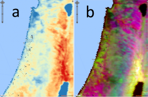
Figure 1. a. May-August median LST. Black polygons are Citrus orchards.
- Colors represent different local climatic conditions (see text).